Signal No. 3 up over parts of Batanes, Babuyan Islands as Neneng makes landfall

Tropical Cyclone Wind Signal (TCWS) No. 3 was raised over parts of Batanes and Babuyan Islands on Sunday morning due to Severe Tropical Storm Neneng (international name: Nesat) which made landfall over Calayan Island, Cagayan, PAGASA said in its bulletin.
The areas under TCWS No. 3 are:
- the southern portion of Batanes (Basco, Mahatao, Uyugan, Ivana, Sabtang); and
- Babuyan Islands.
These areas will have storm-force winds in 18 hours which may lead to moderate to significant threat to life and property.
TCWS No. 2 meanwhile was hoisted over the following areas:
- the rest of Batanes;
- the rest of Cagayan;
- Apayao;
- the northern portion of Abra (Tineg, Lacub, Lagayan); and
- Ilocos Norte.
The above-mentioned areas will have gale-force winds in 24 hours that may lead to minor to moderate threat to life and property.
TCWS No. 1 meanwhile is in effect over the following areas:
- the northern and central portions of Isabela (Santa Maria, San Pablo, Maconacon, Divilacan, Palanan, Ilagan City, Tumauini, Cabagan, Santo Tomas, Quezon, Delfin Albano, Mallig, Quirino, Gamu, Roxas, San Mariano, Benito Soliven, Naguilian, Burgos, Reina Mercedes, San Manuel, Aurora, Luna, Cabatuan, San Mateo, Dinapigue, City of Cauayan);
- Kalinga;
- the rest of Abra;
- Mountain Province;
- the northern portion of Ifugao (Aguinaldo, Alfonso Lista, Mayoyao, Hungduan, Banaue); and
- the northern and central portions of Ilocos Sur (Sinait, Cabugao, San Juan, Magsingal, Santo Domingo, San Ildefonso, San Vicente, Santa Catalina, Bantay, City of Vigan, Santa, Caoayan, Narvacan, Nagbukel, Santa Maria, San Esteban, Santiago, Burgos, Banayoyo, Lidlidda, San Emilio, Quirino, Gregorio del Pilar, Galimuyod, City of Candon, Santa Lucia, Salcedo, Cervantes, Suyo, Sigay, Santa Cruz).
Strong winds (strong breeze to near gale strength) will prevail in 36 hours in areas under TCWS No. 1, which may lead to minimal to minor threat to life and property.
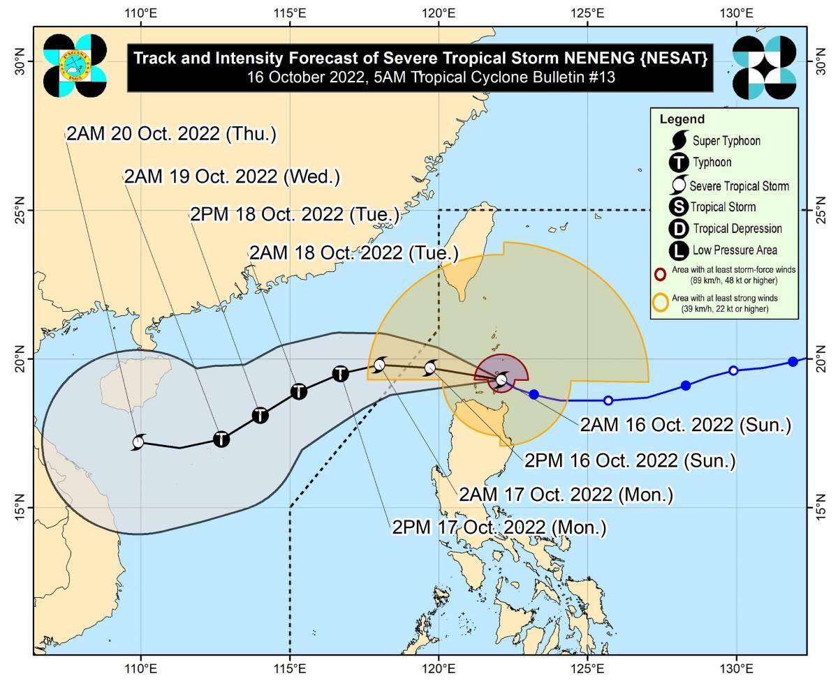
Neneng intensified into a severe tropical storm at 2 a.m. Sunday then made landfall over Calayan Island in Cagayan at 3:50 a.m.
At 4 a.m., the center of Neneng was estimated to be located in the vicinity of Calayan Island, Cagayan.
Neneng has maximum sustained winds of 95 km/h near the center, gustiness of up to 130 km/h, and central pressure of 985 hPa.
The severe tropical storm is moving west northwestward at 20 km/h.
From Neneng's center, strong to storm-force winds are extending outwards up to 550 km.
Heavy rainfall
On Sunday morning until noon, Apayao, Ilocos Norte and the northern portion of Cagayan including Babuyan Islands will likely have heavy to intense with at times torrential rains.
Abra, Kalinga, the northern portion of Ilocos Sur, and the rest of Cagayan will likely have moderate to heavy rains which may be intense at times.
Meanwhile, Batanes, Mountain Province, the rest of Ilocos Sur, and the northern portion of Isabela may possibly have light to moderate with at times heavy rains.
From Sunday noon up to late afternoon, Ilocos Norte may possibly have moderate to heavy rains. Apayao, Abra, and Ilocos Sur meanwhile may experience light to moderate with at times heavy rains.
"Under these conditions, scattered to widespread flooding and rain-induced landslides are likely, especially in areas that are highly or very highly susceptible to these hazard as identified in hazard maps and in localities with significant antecedent rainfall," PAGASA said.
Meanwhile, the western portions of Visayas and Mimaropa and the northern and western portions of Mindanao will have occasional rains on Sunday due to the trough of Neneng and the convergence of its circulation with the southwesterly winds induced by the storm.
Severe winds
"The induced southwesterly winds may also bring occasional gusts reaching strong breeze to near gale strength today over most of Southern Luzon and Visayas and the eastern portions of Central Luzon, especially in coastal and mountainous/upland localities of these areas," PAGASA said.
Coastal waters
PAGASA raised a marine gale warning over the seaboards of Northern Luzon due to the surge of northeasterly surface windflow.
"The aforementioned surge and the approaching tropical cyclone may also bring moderate to rough seas (2.0 to 3.5 m) over the eastern and western seaboards of Central Luzon and the eastern seaboard of Southern Luzon," it added.
These would make sea travel risky for small seacraft. PAGASA advised mariners to take precautionary measures when venturing out to sea, or avoid navigating, if possible.
Track, intensity
Neneng is expected to continue moving westward or west northwestward over the Luzon Strait through Monday early morning.
The severe tropical storm is expected to exit the Philippine Area of Responsibility on Sunday night or early Monday morning.
From there it will begin turning generally west southwestward or southwestward over the West Philippine Sea, PAGASA said.
Neneng is expected to intensify into a typhoon by Monday as it moves over the northern part of the West Philippine Sea.
PAGASA advised the public and disaster risk reduction and management offices concerned to take the necessary measures to protect life and property.
The weather bureau will issue the next bulletin at 8 a.m. —KG, GMA News


