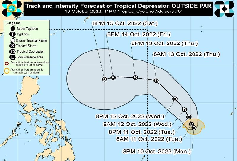
LPA, outside PAR, reclassified to Tropical Depression

The Low Pressure Area (LPA) outside the Philippine Area of Responsibility has developed into a Tropical Depression, according to the Tropical Cyclone Advisory posted by PAGASA late Monday evening.
The center of the Tropical Depression was estimated at 1,620 kilometers east of Eastern Visayas packing maximum sustained winds of 45 kilometers per hour near the center, gustiness of up to 55 km/h, and central pressure of 1006 hPa.
The Tropical Depression is currently moving west southwestward at a speed of 40 km/h with strong winds extending outwards up to 140 km from the center.
General outlook, forecast
"The Tropical Depression will move generally north northwestward in the next 12 hours, then turn northwestward on Wednesday while decelerating over the Philippine Sea," PAGASA reported, adding that the weather disturbance may enter PAR on Thursday morning.
"Once inside the PAR, the domestic name Mamay or Neneng will be assigned to this tropical cyclone depending whether the Low-Pressure Area inside the PAR will develop into a Tropical Cyclone," the weather bureau also said.
The Tropical Depression is forecasted to slow down further and may remain stationary on Thursday as it continues moving westward over the Philippine Sea.
However, the tropical cyclone may intensify once it is over the Philippine Sea and may develop into Tropical Storm category within 72 hours.
"The possibility of hoisting a Tropical Cyclone Wind Signal over Extreme Northern Luzon during the occurrence of this Tropical Depression within the PAR region is not ruled out," PAGASA said.
Rough seas is expected over the northern and eastern seaboards of Luzon beginning Saturday or late Friday, which may be risky for small seacrafts.
Mariners, the bureau said, are advised to continue monitoring for updates while the public and disaster risk reduction and management offices concerned are advised to also continue monitoring. the next advisory will be posted on Tuesday at 11 a.m. -- BAP, GMA News


