

11 areas under Signal 2; Karding likely to turn into typhoon in 12 hours
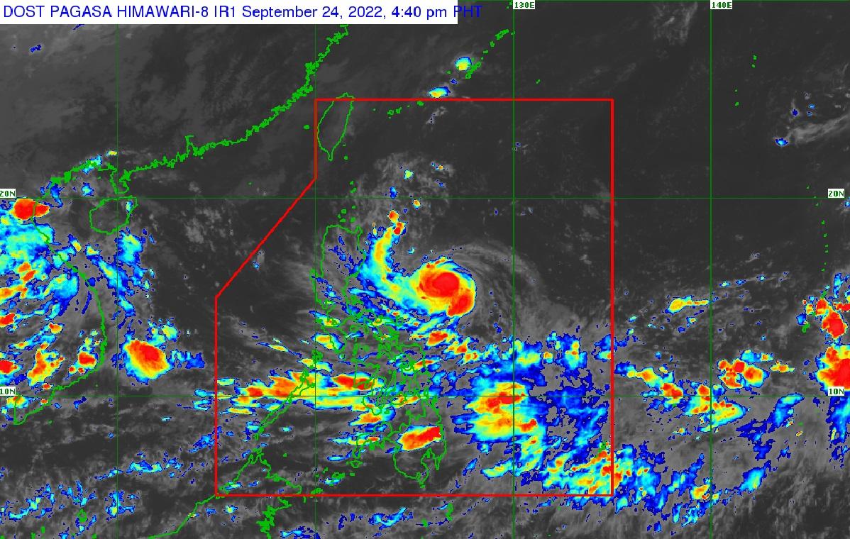
Eleven areas were under Tropical Cyclone Wind Signal 2 as Severe Tropical Storm Karding intensified further while moving west-southwest over the Philippine Sea east of Aurora, and will likely intensify into a typhoon in the next 12 hours, state weather bureau PAGASA said.
In its Saturday afternoon update, PAGASA said that as of 3 p.m., Karding was estimated at 475 km East of Baler, Aurora (15.7°N, 126.8°E), moving West Southwestward at 25 km/h, with maximum sustained winds of 110 km/h near the center and gustiness of up to 135 km/h.
Tropical Cyclone Wind Signal (TCWS) No. 2 was hoisted in the following areas:
- The southeastern portion of Isabela (Dinapigue, Jones, San Agustin, Echague, San Guillermo, San Mariano),
- The southeastern portion of Quirino (Nagtipunan, Maddela),
- The southeastern portion of Nueva Vizcaya (Alfonso Castaneda),
- Eastern portion of Nueva Ecija (Bongabon, Laur, Palayan City, General Tinio, Gabaldon, Pantabangan, Rizal),
- Aurora,
- the eastern portion of Bulacan (Doña Remedios Trinidad, Norzagaray),
- Eastern portion of Rizal (Rodriguez, City of Antipolo, Tanay),
- Eastern portion of Laguna (Santa Maria, Famy, Siniloan, Pangil, Pakil, Paete, Kalayaan, Lumban, Cavinti),
- The northern and central portions of Quezon (General Nakar, Pollilo Islands, Infanta, Real, Mauban, Perez, Alabat, Quezon, Calauag, Tagkawayan, Guinayangan),
- The northwestern portion of Camarines Sur (Del Gallego, Ragay, Lupi, Sipocot),
- and Camarines Norte
Karding's extent will affect the locality with winds of more than 62 km/h, and up to 88 km/h may be expected in at least 24 hours.
TCWS No. 1 is raised in the following areas:
- The southern portion of Cagayan (Peñablanca, Iguig, Tuguegarao City, Enrile, Solana, Tuao, Piat, Amelung, Rizal);
- The rest of Isabela;
- Quirino;
- Nueva Vizcaya;
- The southern portion of Apayao (Conner);
- Abra;
- Kalinga;
- Mountain Province;
- Ifugao;
- Benguet;
- the southern portion of Ilocos Norte (Nueva Era, Badoc, Pinili, Banna, City of Batac, Currimao, Paoay, Marcos);
- Ilocos Sur;
- La Union;
- Pangasinan;
- the rest of Aurora;
- Nueva Ecija;
- Tarlac;
- Bulacan;
- Pampanga;
- Zambales;
- Bataan;
- Metro Manila;
- The northern and central portions of Quezon (Tagkawayan, Lopez, Guinayangan, Gumaca, Pitogo, Unisan, Agdangan, Padre Burgos, Pagbilao, City of Tayabas, Lucban, Sampaloc, Mauban, Atimonan, Plaridel, Perez, Alabat, Quezon, Calauag, Lucena City, General Nakar, Real, Infanta);
- Rizal;
- Laguna;
- Cavite;
- the northern portion of Batangas (Malvar, Balete, City of Tanauan, Santo Tomas, Talisay, Laurel);
- Camarines Norte;
- The northern and eastern portions of Camarines Sur (Del Gallego, Ragay, Lupi, Sipocot, Siruma, Tinambac, Goa, Lagonoy, Garchitorena, Caramoan, Presentacion, San Jose); and
- The northern portion of Catanduanes (Pandan, Caramoan, Bagamanoc, Panganiban, Viga, Gigmoto).
From Saturday evening to early Sunday morning, light to moderate with at times heavy rain would be experienced over the Batanes, Cagayan, Isabela, the northern portion of Aurora, Catanduanes, Camarines Norte, and Camarines Sur.
During the rest of Sunday up to Monday, Karding was expected to bring heavy to intense with at times torrential rains over Aurora, Nueva Ecija, Tarlac, Pangasinan, and the northern portion of Zambales.
Moderate to heavy with at times intense rains could meanwhile be expected over the rest of Central Luzon.
Cagayan, Isabela, Quirino, Nueva Vizcaya, Cordillera Administrative Region, Ilocos Provinces, La Union, Metro Manila, and CALABARZON would meanwhile experience moderate to heavy rain.
These inclement conditions would likely trigger scattered flooding and rain-induced landslides, especially in areas that are highly or very highly susceptible to these hazards.
Also, due to Karding, a Gale Warning was in effect over the eastern seaboards of Luzon.
According to PAGASA's projections, Karding would intensify into a typhoon in the next 12 hours and may further intensify prior to landfall over the east coast of Aurora or northern portion of Quezon on Sunday afternoon.
"While it is likely for this tropical cyclone to slightly weaken due to land interaction during its traverse over Central Luzon, it is highly likely that Karding will remain a typhoon while crossing the landmass," warned PAGASA. —LBG/DVM, GMA News
