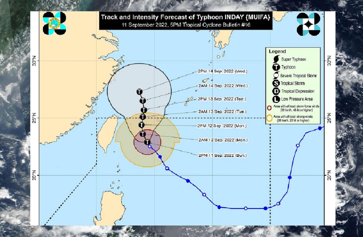
Typhoon Inday keeps strength, moving north-northwestward

Typhoon Inday has maintained its strength as it moves north-northwestward, state weather bureau PAGASA said Sunday afternoon.
At 4 p.m., the center of the eye of Inday was estimated at 360 km northeast of Itbayat, Batanes.
It had maximum sustained winds of 165 km/h near the center, gustiness of up to 205 km/h, and central pressure of 950 hPa, while moving on its track at 10 km/h.
It also sustained a strong to typhoon-force winds that extends outwards up to 310 km from the center.
Rainfall and winds
Inday remains less likely to directly bring heavy rains into the country throughout the forecast period.
However, PAGASA said its outermost rainbands and the Southwest Monsoon may bring rain showers and thunderstorms over Batanes and the western sections of Central and Southern Luzon.
While Tropical Cyclone Wind Signals (TCWS) remain less likely at this time, PAGASA said signals may be raised over portions of extreme northern Luzon as Inday moves further westward and its cyclone winds expand.
Gusty conditions reaching strong to gale-force strength may also be experienced over Extreme Northern Luzon tomorrow due to the channeling of the typhoon circulation in the Luzon Strait.
Coastal waters
Under the influence of Inday, a gale warning remains in effect for the seaboards of Batanes, and Babuyan Islands.
“In the next 24 hours, Inday may also bring moderate to rough seas over the eastern seaboard and the remaining northern seaboard of Northern Luzon (1.2 to 3.0 m),” it said.
“These conditions may be risky for those using small sea crafts. Mariners are advised to take precautionary measures when venturing out to sea and, if possible, avoid navigating [under] these conditions,” it added.
Track
PAGASA’s projections indicate that Inday will move slowly north-northwestward in the next 12 hours before turning northwards by tomorrow toward the vicinity of Yaeyama Islands.
Inday is expected to exit the Philippine Area of Responsibility (PAR) on Tuesday morning or afternoon.
Once outside PAR, the typhoon will move slowly northward while moving over the East China Sea and begin to gradually accelerate north-northwestward on Wednesday afternoon.
It is also forecast to further intensify today through Monday morning.
Then, the slightly cooler waters east of Taiwan and the forecast slow-down period over this sea area may result in a weakening trend beginning late tomorrow or on Tuesday, PAGASA added. —LBG, GMA News


