

Florita now outside PAR, Signal No. 1 remains over 11 areas
Severe Tropical Storm Florita (international name: Ma-on) has exited the Philippine Area of Responsibility (PAR) but Tropical Cyclone Wind Signal (TCWS) No. 1 remains hoisted over 11 areas on Wednesday morning, PAGASA said in its early morning bulletin.
The areas under TCWS No.1 are as follows:
- Batanes;
- Babuyan Islands;
- the western portion of mainland Cagayan (Claveria, Santa Praxedes, Sanchez-Mira, Pamplona, Abulug, Ballesteros, Allacapan, Aparri, Lasam, Santo Niño, Rizal);
- Apayao;
- Abra;
- the western portion of Kalinga (Balbalan, Pasil, Tinglayan);
- the western portion of Mountain Province (Bauko, Tadian, Besao, Sagada, Sabangan, Bontoc, Sadanga);
- the northern and western portions of Benguet (Mankayan, Bakun, Kibungan, Kapangan, Tublay, La Trinidad, Sablan, Tuba, Baguio City, Atok);
- Ilocos Norte;
- Ilocos Sur; and
- La Union.
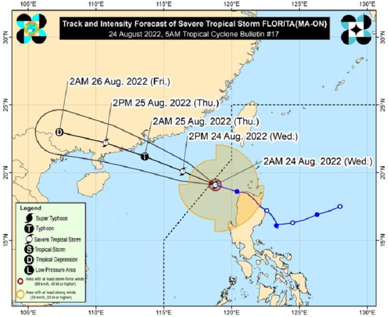
At 4 a.m., the center of Florita was located at 335 km west of Calayan, Cagayan, which is outside PAR.
Florita accelerated west northwestward and was moving at 30 km/h. It has maximum sustained winds of 95 km/h near the center, gustiness of up to 115 km/h, and central pressure of 990 hPa.
From Florita's center, strong to storm-force winds are extending outwards up to 400 km.
On Wednesday morning, moderate to heavy rains are expected over the Ilocos Region, Abra, and Benguet while light to moderate with at times heavy rains may be experienced in the rest of the Cordillera Administrative Region.
Light to moderate with at times heavy rains meanwhile are to be expected over the Ilocos Region on Wednesday afternoon.
The rainfall caused by Florita is forecast to gradually weaken throughout the day. However, there may still be scattered flooding, including flash floods, and rain-induced landslides especially in areas prone to these hazards, and in localities with significant antecedent rainfall.
In the next 24 hours, the Southwest Monsoon or Habagat may continue to bring rains over the western sections of Central and Southern Luzon.
Severe Winds
PAGASA said strong winds will be experienced in any of the areas under TCWS No. 1.
"In the next 24 hours, gusts reaching strong breeze to gale-force strength may still be experienced (especially in the coastal and mountainous areas) over MIMAROPA, Metro Manila, Cavite, Quezon, Bulacan, Pampanga, Pangasinan, Aurora, and localities of Cordillera Administrative Region and Cagayan Valley that are not under any wind signal," it added.
Hazards affecting coastal waters
A gale warning remains in effect over the seaboards of Northern and Central Luzon.
Track, intensity
Florita is expected to move in the west northwest direction over the West Philippine Sea and is forecast to make landfall over the southern part of China on Thursday morning or early afternoon.
The tropical cyclone is also expected to re-intensify and develop into a typhoon on Wednesday night.
PAGASA advised the public and disaster risk reduction and management offices concerned to take the necessary measures to protect life and property.
The weather bureau will issue the next bulletin at 11 a.m.
Classes, work, flights
Classes for Wednesday, August 24, 2022, have been canceled in all levels in public schools in Metro Manila, Cavite, Laguna, Rizal, Bulacan, Zambales, and Bataan due to the onslaught of Florita.
Government office work for Wednesday, August 24, 2022, in the above mentioned areas had also been canceled.
Some flights for Wednesday, August 24, 2022, were also canceled due to bad weather from Florita.
Meanwhile, Binga Dam in Benguet and Magat Dam, which straddles in Ifugao and Isabela, had one gate open each on Wednesday morning to release water. —BAP/KG, GMA News
