

Caloy maintains strength, now outside PAR
Tropical Depression Caloy maintains its strength and is now outside the Philippine Area of Responsibility (PAR), PAGASA reported.
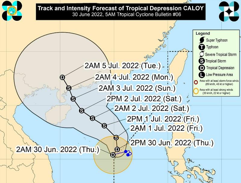
The center of Caloy was estimated 575 km west of Iba, Zambales outside PAR moving westward slowly with maximum sustained winds of 55 km/h near the center and gustiness of up to 70 km/h.
The monsoon trough and the southwest monsoon enhanced by Tropical Depression Caloy will bring monsoon rains over the western sections of Luzon and Visayas.
Bataan, Zambales, Palawan, Oriental Mindoro, Occidental Mindoro, Aurora and Quezon will have monsoon rains due to the monsoon trough / southwest monsoon with possible flash floods or landslides due to scattered to widespread moderate to at times heavy rains.
Metro Manila, the rest of Luzon, and western Visayas will have cloudy skies with scattered rain showers and thunderstorms due to the monsoon trough / southwest monsoon with possible flash floods or landslides due to moderate to at times heavy rains.
The rest of the country will have partly cloudy to cloudy skies with isolated rain showers or thunderstorms due to localized thunderstorm with possible flash floods or landslides during severe thunderstorms.
No tropical cyclone wind signal is hoisted.
Hazards affecting coastal waters
The southwest monsoon enhanced by Caloy will bring moderate to rough seas over the seaboards of northern Luzon and the western seaboards of Central and Southern Luzon.
These conditions may be risky for those using small seacrafts and mariners are advised to take precautionary measures.
Track and Intensity outlook
Tropical Depression Caloy left the PAR at 11 p.m. on Wednesday.
Caloy will track northwestward or west northwestward over the West Philippine Sea on Friday and Saturday. The tropical depression will then move slowly north northwestward on Sunday and Monday towards the southern portion of China, where it is forecast to make landfall.
Caloy is also forecast to reach tropical storm category in the next 24 hours. A peak intensity of around 75 km/h may be reached by Friday evening or Saturday.
