Heavy to intense rain over Catanduanes, eastern Camarines Sur, eastern Albay

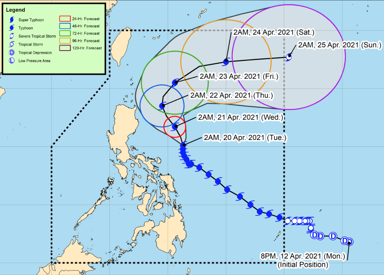
Typhoon Bising further weakens as it continues to move slowly northward, according to the Severe Weather Bulletin posted by PAGASA early Tuesday morning.
Catanduanes, the eastern portion of Camarines Sur and the eastern portion of Albay will be stormy brought about by Bising with possible light to moderate damage to structures and vegetation due to strong winds and flash floods or landslides due to moderate to heavy rains.
Cagayan Valley, the northern portion of Aurora, the eastern portion of Quezon including Polillo Islands, the rest of Bicol Region and the provinces of Samar will experience rains with gusty winds also due to the typhoon with possible light to moderate damage to structures and vegetation due to strong winds and flash floods or landslides due to moderate to heavy rains.
Cordillera Administrative Region, the rest of Aurora and the rest of Quezon will have cloudy skies with scattered rainshowers and thunderstorms due to the typhoon with possible flash floods or landslides during moderate to at times heavy rains.
Metro Manila and the rest of the country will have partly cloudy to cloudy skies with isolated rainshowers due to localized thunderstorms with possible flash floods or landslides during severe thunderstorms
At 4 a.m. on Tuesday, the center of the eye of Typhoon Bising was located at 505 kilometers east of Infanta, Quezon with maximum sustained winds of 175 kilometers per hour near the center and gustiness of up to 215 kph moving northward slowly.
Tropical Cyclone Wind Signal (TCWS) No. 2 is raised over the following areas:
- Catanduanes
- the eastern portion of Camarines Sur (Sagnay, San Jose, Lagonoy, Garchitorena, Presentacion, Caramoan)
- the northeastern portion of Albay (Tiwi, Malinao, Tabaco City, Malilipot, Bacacay, Rapu-Rapu)
Areas under TCWS No. 1 are:
- Batanes
- Cagayan including Babuyan Islands
- Isabela
- Quirino
- Apayao
- the eastern portion of Kalinga (Pinukpuk, Rizal, Tabuk City)
- the extreme eastern portion of Mountain Province (Paracelis)
- the extreme eastern portion of Ifugao (Alfonso Lista)
- the northern portion of Aurora (Baler, Dipaculao, Dinalungan, Casiguran, Dilasag)
- the eastern portion of Quezon (Calauag, Guinayangan, Tagkawayan, Buenavista, San Narciso, San Andres) including Polillo Islands
- Camarines Norte
- the rest of Camarines Sur
- the rest of Albay
- Sorsogon
- the northern portion of Masbate (Aroroy, Masbate City, Baleno, Mobo, Uson, Palanas, Dimasalang) including Burias and Ticao Island
- Northern Samar
- the northern portion of Samar (Tagapul-An, Almagro, Santo Nino, Calbayog City, Santa Margarita, Gandara, Pagsanghan, Tarangnan, San Jorge, San Jose de Buan, Matuguinao)
- the northern portion of Eastern Samar (Maslog, Can-Avid, Dolores, Oras, San Policarpo, Arteche, Jipapad)
Hazards affecting land areas
Tropical cyclone winds of at least strong breeze to near gale in strength extend outward up to 500 km from the center of the typhoon. Destructive typhoon-force winds extend outward up to 110 km from the center of the typhoon.
In the next 24 hours, the northeasterly wind flow enhanced by the typhoon will also bring strong breeze to near gale conditions with higher gusts over the rest of Northern Luzon and the rest of Aurora and Quezon that are not under any wind signal.
Sea travel is risky in areas affected by the typhoon.
In the next 24 hours, Typhoon Bising and an enhanced northeasterly wind flow, very rough to high seas over the northern and eastern seaboards of Luzon and rough to high seas over the northern and eastern seaboards of Eastern Visayas.
Rough to very rough seas over the northern and western seaboards of Northern Luzon and rough seas over the eastern seaboards of Caraga and Davao Oriental and the remaining seaboards of areas under TCWS.
Moderate to rough seas over the western seaboard of Central Luzon.
The typhoon is projected to exit the Philippine Area of Responsibility on Sunday. Bising is forecast to gradually weaken throughout the forecast period and may be downgraded to severe tropical storm by Saturday evening or Sunday early morning.
The sun will rise by 5:40 a.m. and set by 6:11 p.m.
Stranded
Meanwhile, a total of 2,792 passengers, drivers, and cargo helpers were stranded in ports in Eastern Visayas, Bicol, Central Visayas, and north eastern Mindanao due to Bising, the Philippine Coast Guard (PCG) said Tuesday.
In an update, the PCG said 1,032 rolling cargoes were also stranded, while 55 vessels and 54 motorbancas took shelter in these areas amid the bad weather.
Most of the stranded people were reported in Eastern Visayas where 1,185 passengers, drivers, and helpers, as well as 14 vessels and 435 rolling cargoes, were stranded.
This was followed by Bicol with 971 passengers, drivers, and helpers, as well as three vessels and 325 rolling cargoes, that were stranded due to the typhoon. -- BAP/KBK, GMA News

Need a wellness break? Sign up for The Boost!
Stay up-to-date with the latest health and wellness reads.
Please enter a valid email address
Your email is safe with us


