Tonyo heads towards Romblon; Signal No. 1 up over 18 areas

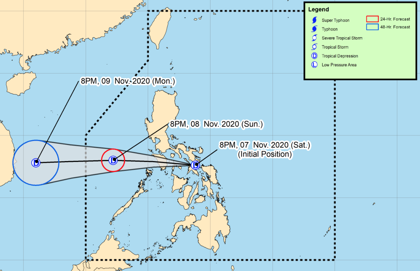
Tropical Depression Tonyo continues to move westward and is now heading towards the vicinity of Romblon, according to the Severe Weather Bulletin issued by PAGASA.
Tropical Depression Tonyo is forecast to move rapidly westward within the next 12 hours and its center is likely to pass close or over the vicinity of Romblon, and Mindoro Provinces. It is forecast to emerge over the West Philippine Sea this morning.
On the forecast track, the tropical depression may exit the Philippine Area of Responsibility (PAR) by Monday morning.
Hazards affecting land areas
On Sunday, Tonyo will bring moderate to heavy rains over Central Luzon, Metro Manila, CALABARZON, Camarines Norte, Marinduque, Mindoro Provinces, and Calamian Islands.
Light to moderate with at times heavy rains will also be experienced over Western Visayas and the rest of Luzon.
Flooding (including flashfloods), rain-induced landslides, and sediment-laden streamflows like lahar may occur during heavy or prolonged rainfall especially in areas that are highly or very highly susceptible to these hazards and/or those that received significant antecedent rainfall from tropical cyclones Pepito, Quinta, and Rolly.
As of 1 a.m. on Sunday, the center of Tropical Depression Tonyo was estimated at 90 kilometers east of Romblon, Romblon or 60 kilometers west northwest of Masbate City, Masbate with maximum sustained winds of 45 kilometers per hour near the center and gustiness of up to 70 kph and moving westward at the speed of 20 kph.
Tropical Cyclone Wind Signal (TCWS) No. 1 is hoisted over the following areas:
Luzon
- Catanduanes
- Camarines Norte
- Camarines Sur
- Albay
- Sorsogon
- Masbate including Ticao and Burias Islands
- the central and southern portions of Quezon (Mauban, Sampaloc, Lucban, Dolores, Tiaong, San Antonio, Candelaria, Sariaya, Tayabas City, Lucena City, Pagbilao, Atimonan, Padre Burgos, Agdangan, Unisan, Plaridel, Pitogo, Macalelon, General Luna, Catanauan, Mulanay, San Francisco, San Andres, San Narciso, Buenavista, Guinayangan, Tagkawayan, Calauag, Lopez, Gumaca, Alabat, Quezon, Perez)
- the central and southern portions of Cavite (Dasmarinas, General Trias, Tanza, Naic, Ternate, Maragondon, Magallanes, General Emilio Aguinaldo, Alfonso, Mendez, Trece Martires City, Indang, Amadeo, Silang, Tagaytay City, Carmona, General Mariano Alvarez)
- the central and southern portions of Laguna (San Pedro, Binan, Santa Rosa City, Cabuyao, Calamba City, Los Baños, Bay, Calauan, Alaminos, San Pablo City, Rizal, Nagcarlan, Victoria, Pila, Santa Cruz, Pagsanjan, Lumban, Kalayaan, Cavinti, Luisiana, Majayjay, Liliw, Magdalena)
- Batangas
- Marinduque
- Romblon
- Oriental Mindoro
- Occidental Mindoro including Lubang Island, and Calamian Islands
Visayas
- the western portion of Northern Samar (San Vicente, Capul, San Antonio, San Isidro, Victoria, Rosario, San Jose, Lavezares, Allen, Biri)
- the northwestern portion of Aklan (Buruanga, Ibajay, Tangalan, Makato, Numancia, Nabas, Malay)
- the northern portion of Antique (Pandan, Libertad, Caluya)
Areas under Tropical Cyclone Wind Signal (TCWS) No. 1 is currently experiencing or will be experiencing strong breeze to near gale conditions with occasional gusts throughout the passage of Tonyo.
The northeast monsoon will also bring strong breeze to near gale conditions over Batanes, Babuyan Islands, Ilocos Norte, Apayao, and the northern portion of mainland Cagayan.
Hazards affecting coastal waters
Moderate to rough seas (1.5 to 3.5 m) due to Tonyo and the prevailing easterlies will be experienced over the seaboards of areas under TCWS No. 1 and the eastern seaboards of Cagayan Valley, Aurora, and the northern portion of Quezon.
The Northeast Monsoon will be bringing moderate to rough seas (2.0 to 3.0 m) over the seaboards of Batanes, Babuyan Islands, Ilocos Norte, and Ilocos Sur and the northern seaboard of mainland Cagayan.
Other tropical systems being monitored
As of 11 p.m. on Saturday, Tropical Depression Atsani weakened into a Low Pressure Area while over the southern portion of the Taiwan Strait and is forecast to dissipate within the next 6 to 12 hours. With this development, this is the final update on this weather disturbance. -- BAP, GMA News


