

Signal No. 2 raised over Batanes, eastern Babuyan Islands as Siony moves towards Luzon Strait
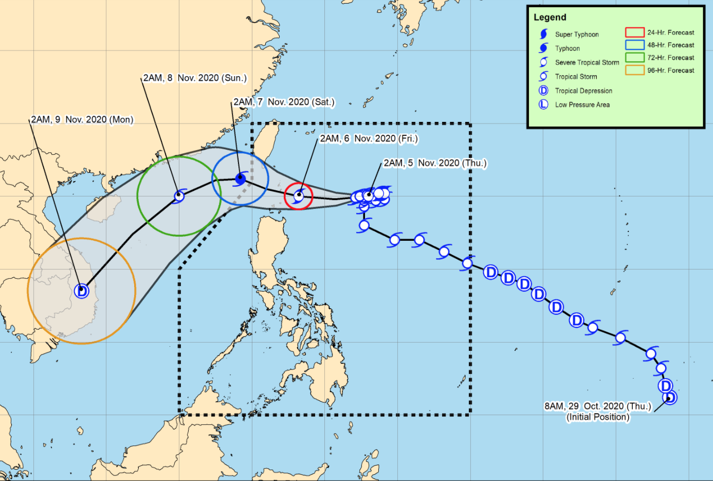
Severe Tropical Storm Siony is moving in the west-southwest direction towards the Luzon Strait, according to the Severe Weather Bulletin issued by PAGASA early Thursday morning.
Siony will accelerate towards the west or west-northwest in the next 48 hours. On the forecast track, the center of Siony will likely pass over or be near the vicinity of Batanes or Babuyan Islands by Friday morning or noon.
After leaving the Philippine Area of Responsibility (PAR) on Friday afternoon or evening, this tropical cyclone is forecast to turn towards the southwest on Saturday morning and accelerate over the West Philippine Sea towards the general direction of central or southern Vietnam.
Siony is forecast to reach typhoon category with a peak intensity of 120 kilometers per hour by Friday morning as it passes near or over the Batanes-Babuyan Islands area.
After exiting the PAR, Siony will gradually weaken due to increasingly unfavorable conditions over the West Philippine Sea associated with a northeasterly surge.
As of 4 a.m. on Thursday, the center of Tropical Storm Goni (formerly Rolly) was estimated at 985 kilometers west of Southern Luzon outside PAR with maximum sustained winds of 75 kilometers per hour near the center and gustiness of up to 90 kph and moving westward slowly towards the southern portion of Vietnam.
Meanwhile, the center of Severe Tropical Storm Siony was estimated based on all available data at 595 kilometers east of Basco, Batanes with maximum sustained winds of 95 kilometers per hour near the center and gustiness of up to 115 kph and moving west southwestward at 10 kph.
Tropical Cyclone Wind Signal (TCWS) No. 2 is hoisted over the following areas:
- Batanes
- the eastern portion of Babuyan Islands (Balintang Island, Babuyan Island, Didicas Island, and Camiguin Island including their adjoining islets)
Tropical Cyclone Wind Signal no. (TCWS) No. 1 is raised over the following areas:
- the rest of Babuyan Islands
- the northern portion of mainland Cagayan (Santa Ana, Gonzaga, Lal-Lo, Allacapan, Santa Teresita, Buguey, Camalaniugan, Aparri, Ballesteros, Abulug, Pamplona, Sanchez-Mira, Claveria, Santa Praxedes)
- the northern portion of Apayao (Santa Marcela, Luna, Calanasan)
- the northern portion of Ilocos Norte (Adams, Pagudpud, Bangui, Dumalneg, Burgos, Vintar, Pasuquin, Bacarra)
Hazards affecting land areas
Strong breeze to near gale conditions due to the prevailing northeasterlies will continue over Batanes, Babuyan Islands, the northern portion of Ilocos Norte, and the northern and eastern coastal areas of mainland Cagayan until the arrival of tropical cyclone winds.
Based on all available meteorological data, the earliest onset of strong breeze to near gale conditions associated with Siony over the areas currently under TCWS No. 2 and No. 1 will be between tonight and tomorrow early morning.
Damaging gale- to storm-force winds will begin to affect areas under TCWS No. 2 on Friday morning.
Based on the intensity outlook for Siony, TCWS No. 3 remains to be the highest wind signal to be hoisted during the passage.
In the next 24 hours, the troughs of both Goni and Siony will bring scattered light to moderate with at times heavy rainshowers over Pangasinan and most parts of Central Luzon, Metro Manila, CALABARZON, MIMAROPA, Bicol Region, Visayas, and Mindanao.
Moderate to heavy rains due to Siony will begin affecting Batanes and Babuyan Islands early Friday morning.
Flooding (including flashfloods) and rain-induced landslides may occur during heavy or prolonged rainfall especially in areas identified in geohazard maps as highly or very highly susceptible to these hazards.
Hazards affecting coastal waters
In the next 24 hours, the coastal waters of areas where TCWS No. 2 and No. 1 are in effect will have rough to high seas (3.0 to 7.0 m), while areas under gale warning will be experiencing rough to very rough seas (2.5 to 5.5 m).
Sea travel is risky over these waters for all types of seacrafts in areas under TCWS and for small seacrafts in areas under gale warning.
Moderate to rough seas (1.5 to 2.5 m) will be experienced over the western seaboards of Central and Southern Luzon and the eastern seaboards of Visayas and Mindanao. Mariners of small seacrafts are advised to take precautionary measures when venturing out to sea. Inexperienced mariners should avoid navigating in these conditions.
