Siony maintains strength over Philippine Sea; Rolly now outside PAR

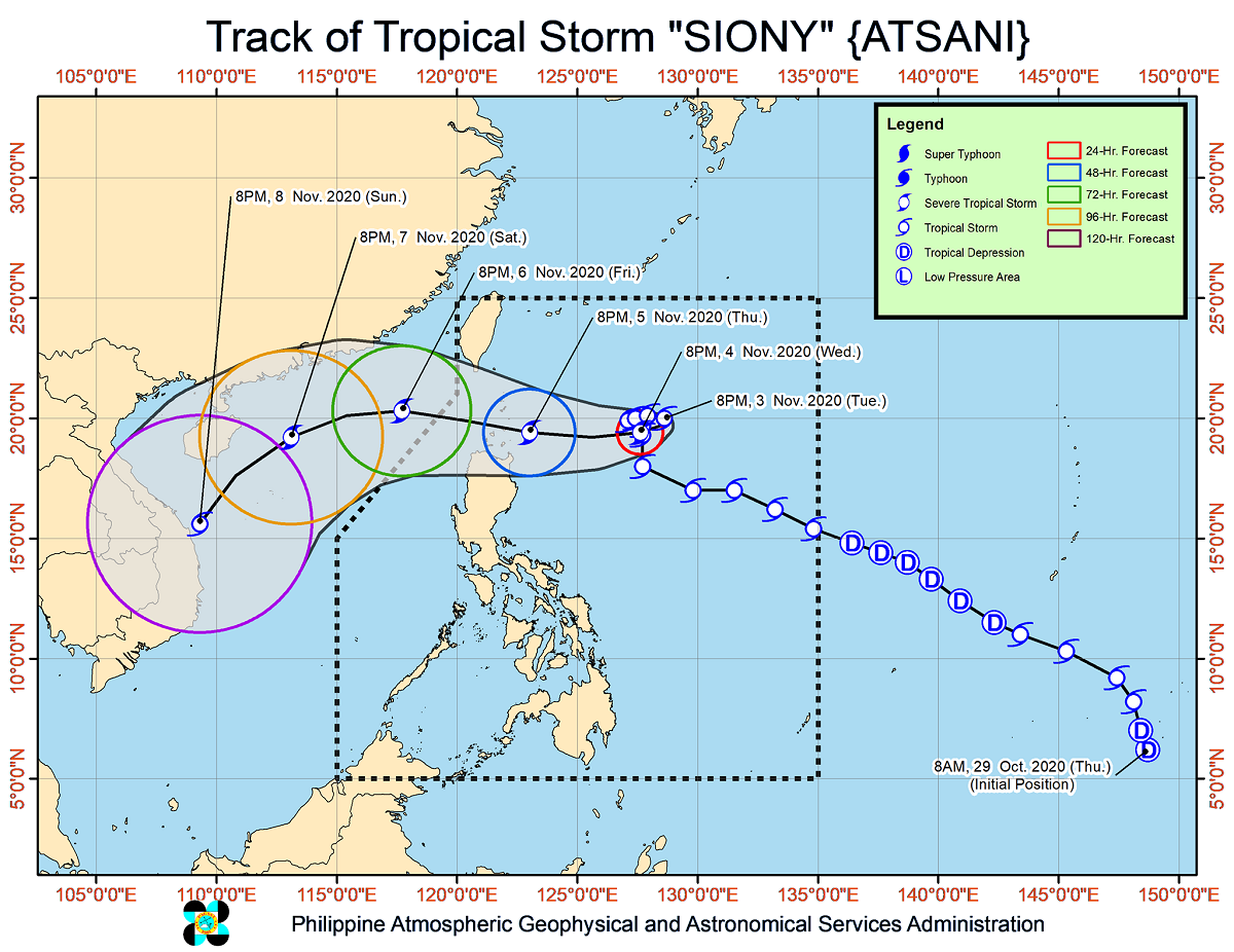
Tropical Storm Siony (international name Atsani) maintains its strength while moving eastward over the Philippine Sea east of extreme northern Luzon, PAGASA said Tuesday.
In its 11 p.m. severe weather bulletin, the weather agency said Siony is forecast to intensify into a severe tropical storm in the next 24 to 36 hours and reach its peak intensity of 100 to 110 kilometers per hour on Thursday before landfall or close approach over northern Luzon.
PAGASA said it is not ruling out further intensification into a typhoon.
At 10 p.m. on Tuesday, the center of Siony was estimated at 665 kilometers east of Basco, Batanes with maximum sustained winds of 85 kph near the center and gustiness of up to 105 kph.
It is moving eastward at 10 kph.
The weather agency said the center of Siony will be over or very close to Batanes and the Babuyan Island between Thursday night and Friday morning, making landfall over the areas likely.
Siony is forecast to exit the Philippine Area of Responsibility (PAR) on Friday afternoon or evening.
Meanwhile, according to a separate severe weather bulletin, tropical storm Rolly has exit PAR at 8 p.m. on Tuesday.
It is forecast to move westward or southwestward over the West Philippine Sea toward the southern portion of Vietnam. Rolly may also weaken into a tropical depression before landfall over Southern Vietnam due to unfavorable conditions.
The center of Rolly was estimated at 615 km west of Subic Bay with maximum sustained winds of 75 kph near the center and gustiness of up to 90 kph.
It is moving westward slowly.
Hazards
In the next 24 hours, the northeasterlies are expected to bring strong breeze to gale-force winds with higher gusts over Batanes, Babuyan Islands, and the northern coastal areas of Cagayan and Ilocos Norte.
Meanwhile, Tropical Cyclone Wind Signal (TCWS) no. 1 may be raised over some provinces in the Cagayan Valley on Wednesday morning due to possible strong breeze to near gale conditions.
Rough to very rough seas will also prevail over the entire seaboards of Northern Luzon and the Kalayaan Islands due to the combined effects of Rolly and Siony as well as the northeasterlies.
PAGASA said sea travel is “risky.”
Meanwhile, moderate to rough seas may prevail over the eastern and western seaboards of Central and Southern Luzon and the eastern seaboards of Visayas and Mindanao.
“Mariners of small seacrafts are advised to take precautionary measures when venturing out to sea. Inexperienced mariners should avoid navigating in these conditions,” PAGASA said.
A severe weather bulletin on Siony is set to be issued at 11 a.m. on Wednesday. — Joahna Lei Casilao/BM, GMA News


