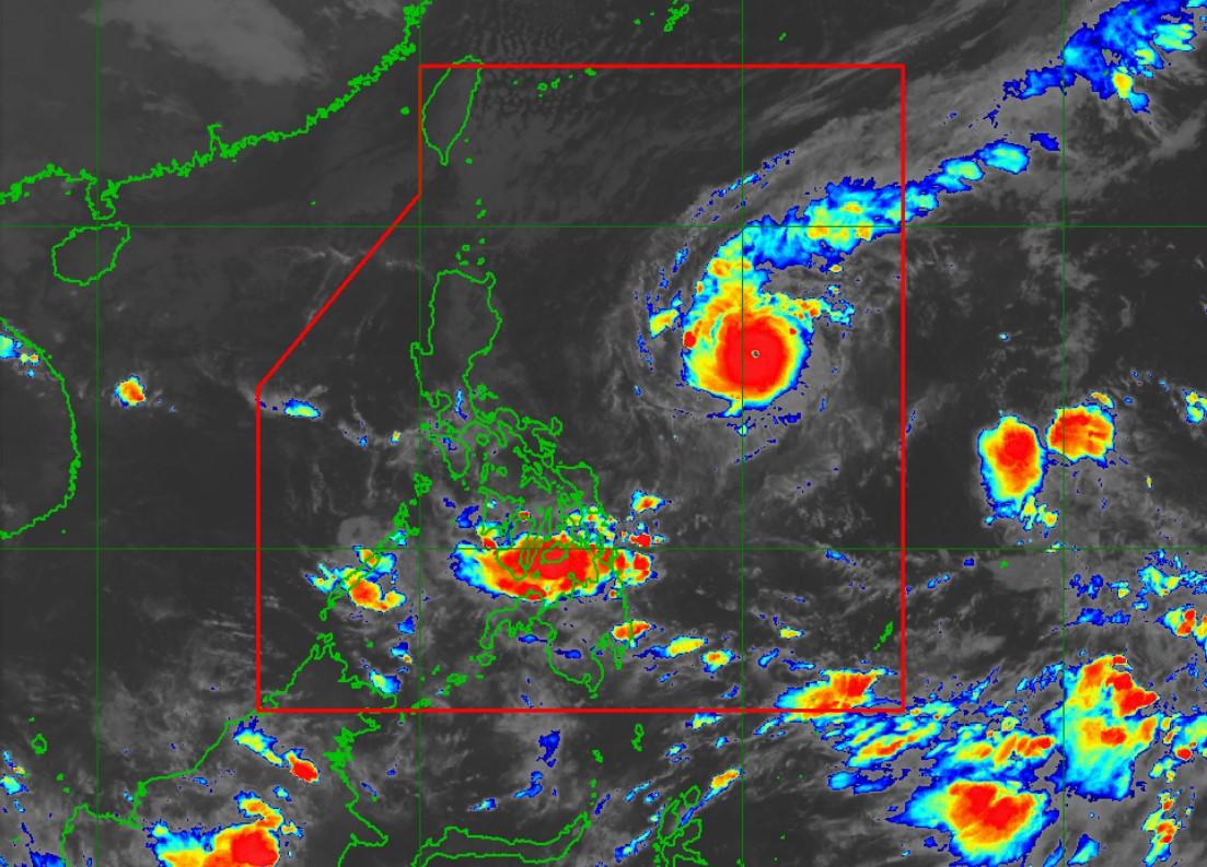
Rolly likely a super typhoon in 12 hours, more areas under Signal No. 1

Typhoon Rolly continues to rapidly gain strength and is nearing super typhoon status as it moved west-southwestward toward Luzon on Friday night, PAGASA has said.
In its 11 p.m. severe weather bulletin, the weather agency said Rolly could intensify into a super typhoon within 12 hours “owing to very favorable conditions.”
More areas have been placed under Signal No. 1. These are:
- Catanduanes
- Camarines Norte
- Camarines Sur
- Albay, Sorsogon
- Masbate (including Ticao and Burias Islands)
- Quezon (including Polillo Islands)
- Rizal
- Laguna
- Marinduque
- Romblon
- Northern Samar
- The northern portion of Samar (Tagapul-An, Almagro, Santo Nino, Tarangnan, Catbalogan City, Calbayog City, Santa Margarita, Gandara, Pagsanghan, San Jorge, Jiabong, Motiong, Paranas, San Jose de Buan, Matuguinao)
- The northern portion of Eastern Samar (Taft, Can-Avid, Dolores, Maslog, Jipapad, Arteche, Oras, San Policarpo)
- The northern portion of Biliran (Kawayan, Maripipi)
PAGASA said Signal No. 2 could be raised in some provinces in the Bicol Region in the next bulletin. The highest storm signal that may be issued is TCWS no. 4.
The center of Rolly is forecast to pass very close or over the Calaguas Islands on Sunday afternoon and make landfall over the Quezon-Aurora area on Sunday evening.
“The typhoon is forecast to be near Super Typhoon strength (185-215 km/h) by time it passes very near to Bicol Region and makes landfall over the Aurora-Quezon area,” PAGASA said.
Though Rolly is forecast to weaken after landfall, it will remain as a typhoon until it emerges over the West Philippine Sea. It may exit the mainland Luzon landmass on Monday morning
At 10 p.m. on Friday, Rolly was located at 895 kilometers east of Casiguran, Aurora with maximum sustained winds of 215 kilometers per hour near the center and gustiness of up to 265 kph.
It is moving west-southwestward at 15 kph.
The next severe weather bulletin on Rolly is set to be issued at 5 a.m. on Saturday.
Hazards affecting land
From Friday night to Saturday morning, the trough of Rolly is expected to bring light to moderate with, at times, heavy rains over the Visayas, Palawan (including Cuyo Islands), the Zamboanga Peninsula, Northern Mindanao, Caraga, and the Sulu archipelago.
Heavy to intense rains may, meanwhile, be experienced over the Bicol Region, CALABARZON, Metro Manila, Marinduque, and the northern portions of Occidental and Oriental Mindoro from Saturday evening to Sunday morning.
PAGASA warned affected residents of flooding, rain-induced landslides, and sediment-laden streamflows that may occur during heavy or prolonged rainfall.
Meanwhile, strong breeze to near gale conditions may prevail over Batanes, Babuyan Islands, Ilocos Norte, Apayao, and the coastal and mountainous areas of Cagayan and Isabela due to the northeasterlies.
Hazards affecting coastal waters
According to the weather agency, rough to phenomenal seas will prevail over the seaboards of areas under Signal No. 1.
Meanwhile, rough to high seas are expected over seaboards of Northern and Central Luzon and the eastern seaboards of Eastern Visayas and Caraga while moderate to rough seas may prevail over the remaining seaboards in the country.
PAGASA advised those with small sea crafts to take precautionary measures while "inexperienced mariners" should refrain from sea voyage.
Other tropical systems
Meanwhile, Tropical Storm Atsani has weakened into a tropical depression outside the Philippine Area of Responsibility (PAR).
Despite this, PAGASA said it is likely to re-intensify into a tropical storm within the next 24 to 48 hours.
It was estimated at 1,790 km east of Visayas with maximum sustained winds of 55 kph near the center and gustiness of up to 70 kph.
The tropical depression is moving northwestward at 25 kph and is forecast to enter PAR on Sunday. -NB, GMA News


