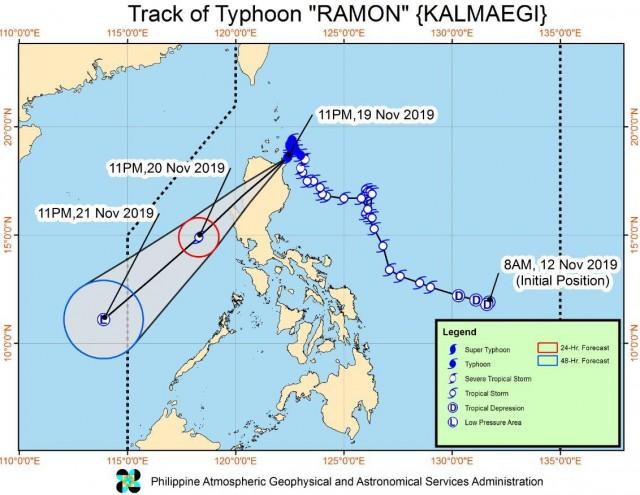
Ramon makes landfall; expect high waves, frequent heavy rains over affected areas

Typhoon Ramon makes landfall in Santa Ana, Cagayan at 12:20 a.m. and continues to move southwestward, PAGASA reported early Wednesday morning.
Ramon is forecast to significantly weaken throughout the forecast period due to land interaction and the Northeast Monsoon.
On Tuesday, moderate with occasional to frequent heavy rains is expected over Batanes, Cagayan including Babuyan Islands and Apayao.
Light to moderate with intermittent heavy rains over Ilocos Norte, Ilocos Sur, Abra, Mt. Province, Kalinga, and the northern portion of Isabela.
As of 1 a.m. on Tuesday, the eye of Typhoon Ramon was located at in the vicinity of Santa Ana, Cagayan packing maximum sustained winds of 120 kilometers per hour near the center, gustiness of up to 150 kph and moving southwest at 10 kph.
Tropical Cyclone Wind Signal (TCWS) No. 3 is hoisted over the following areas:
- Northern portion of Cagayan (Santa Praxedes, Claveria, Sanchez Mira, Pamplona, Abulug, Ballesteros, Aparri, Calayan, Camalaniugan, Buguey, Santa Teresita, Gonzaga, Santa Ana, Allacapan, Lal-lo, Gattaran, Lasam, Baggao, Alcala, and Santo Niño)
The areas under TCWS No. 2 are:
- Batanes
- Apayao
- Kalinga
- Abra
- Ilocos Norte
- Ilocos Sur
- and the rest of Cagayan
The areas under TCWS No. 1:
- Northern portion of Isabela (Sta. Maria, San Pablo, Maconacon, Cabagan, Sto. Tomas, Quezon, Delfin Albano, Tumauini, Divilacan, Quirino, Roxas, Mallig, San Manuel, Burgos, Gamu and Ilagan City)
- Mountain Province
- Benguet
- Ifugao
- La Union
- Pangasinan
Coastal flooding may be experienced in the coastal areas under TCWS No. 3 and No. 2 due to high waves near the coast.
Sea travel is risky, especially for small sea crafts, over the seaboards of areas under TCWS, the seaboard of southern Isabela, and the western seaboard of Zambales and Bataan due to prevailing or forecast rough sea conditions.
Residents in these areas, especially those living in areas identified to be highly or very highly susceptible to flooding and rain-induced landslides, are advised to take appropriate actions, coordinate with local disaster risk reduction and management offices, and continue monitoring for updates.
The next Severe Weather Bulletin on Typhoon Ramon and Tropical Depression Sarah will be issued by the weather bureau about 5 a.m. on Wednesday. — BAP, GMA News


