

Storm surge warnings up in eastern Visayas, Luzon on Nona's approach

Typhoon Nona (international name Melor) continues to draw closer to Samar Monday morning and may make landfall in Sorsogon in the afternoon, prompting state weather forecasters to hoist storm surge warnings ahead of its path.
The provinces of Albay, Biliran, Camarines Norte, Camarines Sur, Leyte, Masbate, Samar, Sorsogon, and Southern Quezon may experience storm surges up to 4 meters in height—the equivalent of a two-storey building—within the next 24 hours, between Monday and Tuesday morning.
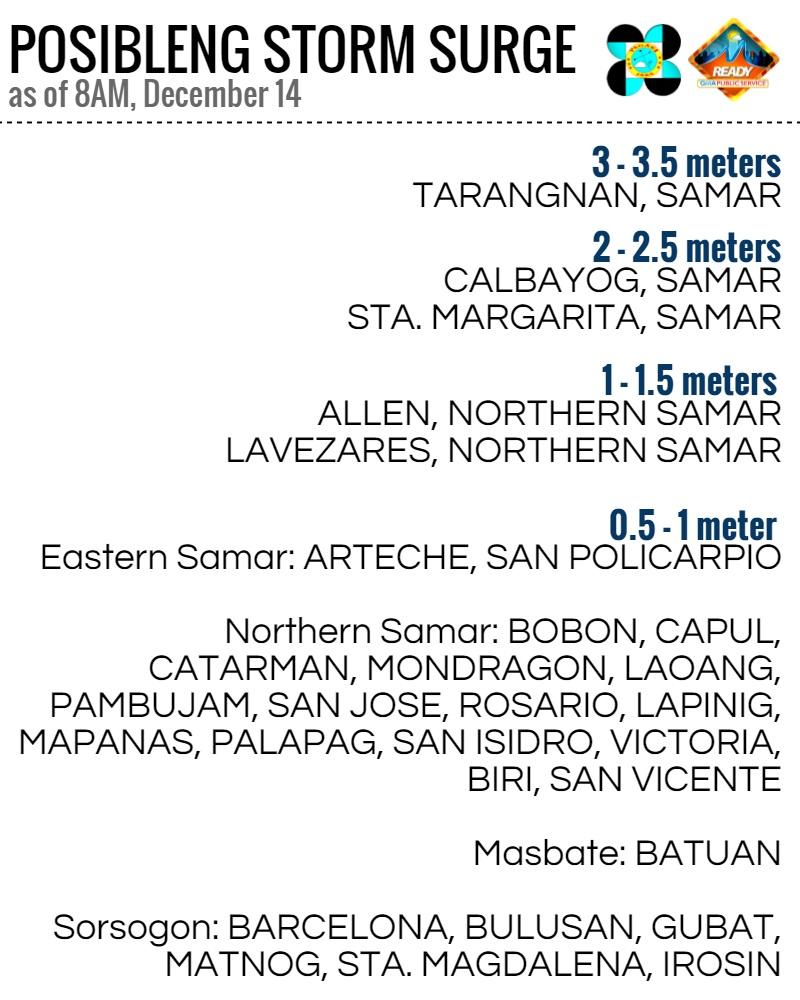
As of 8 a.m. Monday, Samar is expected to be the worst hit by storm surges:
Nona's forecast track
As of 9 a.m., PAGASA posited Nona some 95 km east of Catarman, Northern Samar with winds of up to 115 kph and gusts of up to 185 kph within its 300-km radius. It is still moving east at 17 kph.
"Mataas ang tsansa na mag-landfall si Nona sa Sorsogon mamayang hapon," said GMA resident meteorologist Nathaniel "Mang Tani" Cruz.
Various international weather agencies are now in general agreement over Nona's forecast track.
"Inaasahang dadaan ito sa may Albay, Marinduque, at Mindoro sa mga susunod na araw. Pagdating ng Miyerkules ng umaga, inaasahang nakaalis na ito ng lupa at nasa West Philippine Sea na ito," Mang Tani said, underscoring PAGASA's own forecast.
Similar to previous storms
Mang Tani said that Nona's track is similar to that of Reming in 2006, which battered Albay and Bicol.
"Batay sa rainfall forecast map ng Metra, matinding pag-ulan ang maaasahan sa Bicol at MIMAROPA ngayong araw dahil kay Nona. Mayroon ding matinding pag-ulan sa Leyte maghapon," he said.
Aside from eastern Philippines, Metro Manila should also brace for heavy rains and strong winds this Tuesday and Wednesday. Residents of the NCR and nearby provinces are advised to temporarily take down their Christmas ornaments.
"Nona is expected to bring up to 150 kph winds to Metro Manila, similar to what happened with Typhoon Glenda in 2014," said IM Ready consultant Dr. CP David.
"May mataas na tsansa ng ulan mamayang hapon sa NCR, pero asahan ding mas maulan ngayong Martes at Miyerkules sa Metro Manila dahil kay Nona," Mang Tani added.
'A very compact typhoon'
About 8,000 people were stranded in ports after the coast guard stopped all ferry services and fishing in the central Philippines.
"(Nona) is a very compact typhoon, so that will prevent its most devastating impacts from extending too far from its center," said AccuWeather meteorologist Adam Douty.
He said the typhoon had weakened a little as it encountered drier air early on Monday. "While Melor will not slam onshore as a super typhoon as once feared, it still poses dangers to lives and property," Douty said.
Alexander Pama, executive director of the National Disaster Risk Reduction and Management Council, said Typhoon Nona was expected to cause flooding, landslides and storm surges of up to 4 meters (13 feet) and disrupt power and communications.
About 20 provinces, including around the capital, Manila, are under public storm alert due to strong winds and torrential rains of up to 300 mm (12 inches) within a 300 km (185 miles) radius.
About 20 major typhoons pass through the Philippines each year. — GMA News
