Filtered By: Scitech
SciTech
Typhoon Lando to weaken but linger in Luzon until Wednesday
By TJ DIMACALI, GMA News


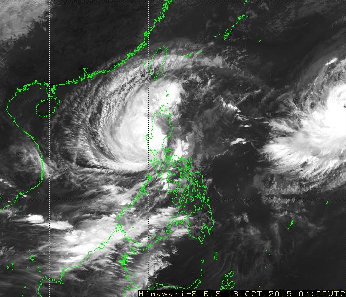
After coming down hard and fast in Casiguran, Aurora, early Sunday, Typhoon Lando (international name Koppu) is weakening but will still bring rain to the country for most of next week.
"Hihina si Lando dahil sa pagtama nito sa kalupaan, lalo na dahil sa pagtama nito sa mga bundok ng Cordillera, pero mabagal din ang paglabas nito sa bansa," explained GMA resident meteorologist Nathaniel "Mang Tani" Cruz.
As of 6 a.m., Lando was in the area of Pantabangan, Nueva Ecija, with sustained winds of 150 kph and gusts of up to 185 kph.
But Lando is moving at a very slow 5 kph even as it is starting to turn northward on a lingering path through most of northern Luzon.
"Bukas (Monday) nasa Northern Luzon ito, at sa Tuesday nandoon pa rin ito," said PAGASA forecaster Aldczar Aurelio in a televised interview Sunday morning.
Lando is expected to weaken into a tropical storm by Tuesday and exit Luzon on Wednesday in the area of Cagayan. However, it is expected to remain in the Philippine Area of Responsibility (PAR) and continue to affect the country until Friday.
Revised storm signals
The cyclone's weakening has prompted PAGASA to revise its storm signal warnings as of Sunday, 11 a.m.
Storm Signal No. 4 has been lifted in Aurora, but the province is still under storm warning.
Storm Signal No. 3 is up in the following areas, which can expect up to 170 kph winds within the next 18 hours:
- Aurora
- Quirino
- Nueva Vizcaya
- Nueva Ecija
- Benguet
- Ifugao
- Mountain Province
- Kalinga
- La Union
- Pangasinan
Storm Signal No. 2 is up in the following areas, which can expect up to 120 kph winds in 24 hours:
- Metro Manila
- Cagayan, including Calayan and Babuyan group of Islands
- Isabela
- Abra
- Apayao
- Ilocos Norte
- Ilocos Sur
- Zambales
- Bataan
- Tarlac
- Pampanga
- Bulacan
- Rizal
- Northern Quezon, including Polillo Islands
Storm Signal Warning No. 1 is up in these areas, which will experience up to 60 kph winds in 36 hours:
- Batanes
- Cavite
- Laguna
- Batangas and rest of Quezon
Storm surges, landslide warnings
Because of Lando's persistent rains, landslide warnings have been raised across Luzon. The Moutain Provinces and the rest of the Cordilleras are particularly vulnerable.
Storm surges may be expected along the coasts of areas under Storm Signal No. 2 and greater. Generally, the waters off Luzon and Visayas as well as those off northern and eastern Mindanao will continue to experience dangerously rough seas.
SEVERE WEATHER BULLETIN No. 14FOR: TYPHOON “#LandoPH”TROPICAL CYCLONE: WARNINGISSUED AT 11:00 AM, 18 OCTOBER 2015...
Posted by Dost_pagasa on Saturday, October 17, 2015
As of 11 a.m. Sunday, the JTWC forecast Lando to weaken as it makes its way through the Cordillera Mountains over the day. From a strength of 185 kph Saturday morning, it is expected to drop to 130 kph by evening.
This weakening is expected to continue as Lando moves over land.
The Japan Meteorological Agency (JMA) also expects a similar weakening over the day. — GMA News
More Videos
Most Popular


