

PhilSA releases map showing possible extent of Bataan oil spill
The Philippine Space Agency (PhilSA) released a map on Friday showing the potential size of the oil spill from the sunken tanker off the coast of Bataan.
It includes the tanker's location as well as a satellite image of the oil leak that was taken at 5:40 a.m., PhilSA said, adding that the slick covers an area of 14.4 square kilometers.
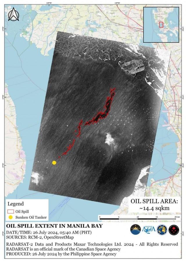
The image was retrieved from the International Charter Space and Major Disasters, which provides Earth-observation satellite data to support disaster management efforts.
''Please be advised that this map is still subject to field validation,'' PhilSA said.
The MT Terra Nova departed Bataan for Iloilo when it capsized 3.6 nautical miles east off Limay town around 1:10 a.m. Thursday.
According to the Philippine Coast Guard, 16 of the 17 crew members were rescued, while one crewman was found dead.
On Friday, the PCG said it started collecting oil to counter the spread of the spill.
''There are oil spill booms in the area, there are dispersants, and there are environmental protection personnel,'' PCG spokesperson Rear Admiral Armand Balilo told reporters.
Balilo said that the oil spill was coming from the working fuel of the motor tanker and not from the 1.4 million liters of stored industrial oil.
In a worst-case scenario in which the cargo of 1.4 million liters of industrial oil leaked from the motor tanker, Balilo said the waters of Parañaque, Manila, Navotas, Bulacan, and Pampanga would be affected.
“We are utilizing our manpower, mobilizing our resources, consulting with experts, and collaborating with LGUs (local government units) and other stakeholders to avoid a marine environment catastrophe,” Balilo said. —VBL, GMA Integrated News
