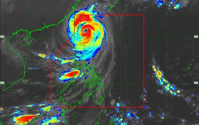
PAGASA: Heavy rainfall over extreme N. Luzon as Leon passes close to Batanes

Violent conditions continue over extreme Northern Luzon as Super Typhoon Leon passes close to Batanes, according to the Tropical Cyclone Bulletin released by PAGASA.
As of 4 a.m., the center of the eye of Super Typhoon Leon was estimated at 100 kilometers east northeast of Itbayat, Batanes packing maximum sustained winds of 195 kilometers per hour near the center, gustiness of up to 240 km/h, and central pressure of 920 hPa.
Leon continues to move northwestward at the speed of 20 kph with strong to typhoon-force winds extend outwards up to 600 km from the center.
Tropical Cyclone Wind Signal (TCWS) No. 5 is hoisted over the following areas:
- the northern and eastern portions of Batanes (Itbayat, Basco)
TCWS No. 4 is hoisted over the following areas:
- the rest of Batanes
TCWS No. 3 is hoisted over the following areas
- the northern portion of Babuyan Islands (Babuyan Is., Calayan Is.)
TCWS No. 2 is hoisted over the following areas:
- the rest of Babuyan Islands
- mainland Cagayan
- the northern portion of Isabela (San Pablo, Maconacon, Divilacan, Palanan)
- Apayao
- Ilocos Norte
TCWS No. 1 is hoisted over the following areas:
- the rest of Isabela
- Quirino
- the northern and central portions of Nueva Vizcaya (Bayombong, Dupax del Norte, Ambaguio, Bagabag, Villaverde, Kayapa, Santa Fe, Kasibu, Aritao, Bambang, Diadi, Dupax del Sur, Quezon, Solano)
- Abra
- Kalinga
- Mountain Province
- Ifugao
- Benguet
- Ilocos Sur
- La Union
- the northern and central portions of Aurora (Casiguran, Dinalungan, Dipaculao, Dilasag)
Heavy Rainfall Outlook
PAGASA reported intense to torrential rains over Batanes, heavy to intense rain over Babuyan Islands, Occidental Mindoro, and Calamian Island and moderate to heavy rainfall over Ilocos Norte, Ilocos Sur, Benguet, La Union, Pangasinan, Zambales, and Bataan.
Severe Winds
The wind signals warn the public of the general wind threat over an area due to the tropical cyclone. Local winds may be slightly stronger/enhanced in coastal and upland/mountainous areas exposed to winds. Winds are less strong in areas sheltered from the prevailing wind direction.
Extreme impacts from typhoon-force winds are expected within any of the areas under Wind Signal No. 5, significant to severe impacts from typhoon-force winds are possible within any of the areas under Wind Signal No. 4 while moderate to significant impacts from storm-force winds are possible within any of the areas under Wind Signal No 3.
Meanwhile, minor to moderate impacts from gale-force winds are possible within any of the areas under Wind Signal No. 2 and minimal to minor impacts from strong winds are possible within any of the areas under Wind Signal No. 1.
PAGASA also reported that the wind flow coming towards the circulation of Leon will also bring gusty conditions (strong to gale-force) over the following localities (especially in coastal and upland areas exposed to winds) outside Wind Signal areas: Most of Cordillera Administrative Region, Quirino, Nueva Vizcaya, Aurora, Bataan, Metro Manila, CALABARZON, MIMAROPA, Bicol Region, Northern Samar and most of Western Visayas.
Coastal Inundation
The state weather bureau also reported that within the next 48 hours, there is a high risk of life-threatening storm surge with peak heights exceeding 3.0 m above normal tide levels over the low-lying or exposed coastal localities of Batanes and Babuyan Islands.
Hazards affecting coastal waters
A Gale Warning is hoisted over the seaboard of Northern Luzon and the eastern seaboards of Central Luzon.
Sea travel is risky all types or tonnage of vessels. All mariners are advised to take precautionary measures while venturing out to sea and, if possible, avoid navigation under these conditions.
Track and Intensity outlook
Super Typhoon Leon is forecast to move northwestward over the seas of Extreme Northern Luzon until it makes landfall along the eastern coast of Taiwan by Thursday afternoon.
After crossing the landmass of Taiwan, Leon will then turn northward to north northeastward over the Taiwan Strait towards the East China Sea and exit the Philippine Area of Responsibility tonight or tomorrow early morning.
"Leon will be closest to Batanes within the next 3 hours, but the landfall scenario in Batanes is now becoming less likely," said PAGASA. — BAP, GMA Integrated News


