
Stormy weather over eastern portions of Cagayan, Isabela due to Bising
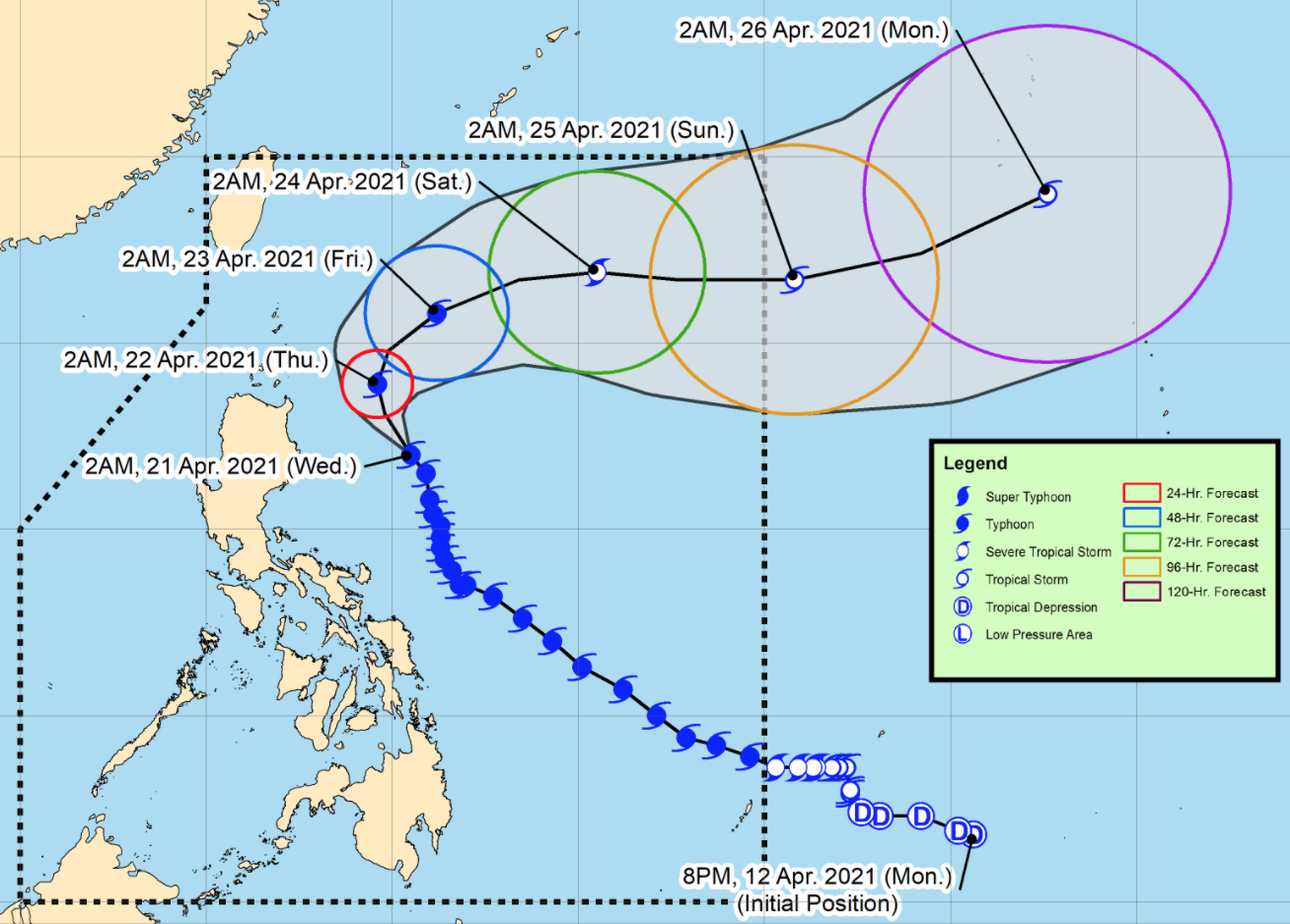
Typhoon Bising moves in the north-northwest direction over the Philippine Sea east of mainland Cagayan Valley, according to the Severe Weather Bulletin posted by PAGASA early Wednesday morning.
The eastern portions of Cagayan and Isabela will be stormy on Wednesday brought about by Typhoon Bising with possible light to moderate damage to structures and vegetation due to strong winds and flash floods or landslides due to moderate to heavy rains.
The rest of Cagayan Valley, Apayao, Kalinga, the eastern portion of Mountain Province, the eastern portion of Ifugao, Aurora, Camarines Provinces, Catanduanes, and Polillo Islands will have rains with gusty winds also due to the typhoon with possible light to moderate damage to structures and vegetation due to strong winds and flash floods or landslides due to moderate to heavy rains.
The rest of Cordillera Administrative Region, Ilocos Norte, Nueva Ecija, Albay, and the rest of Quezon will have cloudy skies with scattered rainshowers and thunderstorms due to Bising with possible flash floods or landslides during moderate to at times heavy rains.
Metro Manila and the rest of the country will have partly cloudy to cloudy skies with isolated rainshowers due to localized thunderstorms with possible flash floods or landslides during severe thunderstorms.
As of 4 a.m. on Wednesday, the center of the eye of Typhoon Bising was located at 395 kilometers east of Tuguegarao City, Cagayan with maximum sustained winds of 175 kilometers per hour near the center and gustiness of up to 215 kph and moving north northwestward at 15 kilometers per hour.
Tropical Cyclone Wind Signal (TCWS) No. 2 is hoisted over the following areas:
- the eastern portion of Cagayan (Santa Ana, Gonzaga, Baggao, Gattaran, Lal-Lo, Peñablanca, Santa Teresita, Buguey)
- the eastern portion of Isabela (Maconacon, Divilacan, Palanan)
The areas under TCWS No. 1 are the following:
- Batanes
- the rest of Cagayan including Babuyan Islands
- the rest of Isabela
- Quirino
- Apayao
- the eastern portion of Kalinga (Rizal, Tabuk City, Pinukpuk, Tanudan)
- the eastern portion of Mountain Province (Paracelis, Natonin)
- the eastern portion of Ifugao (Alfonso Lista, Aguinaldo)
- the northern and central portion of Aurora (Dipaculao, Baler, Dinalungan, Casiguran, Dilasag)
- Polillo Islands
- the northern portion of Camarines Norte (Capalonga, Jose Panganiban, Paracale, Vinzons, Talisay, Daet, Mercedes, Basud)
- the northeastern portion of Camarines Sur (Siruma, Tinambac, Lagonoy, Garchitorena, Caramoan)
- the northern portion of Catanduanes (Caramoran, Viga, Gigmoto, Panganiban, Bagamanoc, Pandan)
Hazards affecting coastal waters
In the next 24 hours, under the influence of the typhoon and an enhanced northeasterly wind flow, the following sea conditions will be experienced over the coastal waters of the country and mariners and seacraft owners are warned that sea travel is risky.
Rough to high seas will be experienced over the northern and eastern seaboards of Luzon while rough to very rough seas is also the forecast over the western seaboards of Northern Luzon and the northern and eastern seaboards of Northern Samar (2.5 to 4.5 m)
Moderate to rough seas over the western seaboard of Central Luzon, the remaining eastern seaboard of Eastern Visayas and the eastern seaboard of Mindanao.
Track and Intensity Outlook
The typhoon is forecast to exit the Philippine Area of Responsibility on Saturday evening or Sunday morning.
Bising is forecast to gradually weaken throughout the remainder of the forecast period. The typhoon will likely be downgraded to severe tropical storm category by Saturday and tropical storm category by Sunday. -- BAP, GMA News
