
Heavy rains expected in northeastern provinces of Luzon due to Ramon
Light to moderate with intermittent heavy rains may be experienced over the eastern portions of Cagayan and Isabela, Northern Aurora, Polillo Islands and Bicol Region on Friday, PAGASA said in its Severe Weather Bulletin on Thursday night.
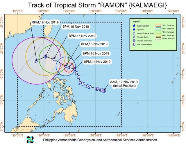
Tropical Storm Ramon continues to move north-northwestward over the Philippine Sea east of northern Aurora.
According to the 11 p.m. advisory, the Tropical Cyclone Wind Signal (TCWS) no. 2 over Catanduanes has been downgraded to TCWS No. 1, while TCWS No. 1 was lifted over Camarines Norte, Camarines Sur, and Albay.
In the latest bulletin, the weather bureau raised and maintained TCWS No. 1 over the following areas:
- Southeastern portion of Cagayan (Peñablanca & Baggao)
- Eastern portion of Isabela (Divilacan, Palanan, Dinapigue & Maconacon)
- Northern Aurora (Dilasag, Casiguran, Dinalungan)
- Polillo Island
- Catanduanes
PAGASA advised residents of the areas identified to be susceptible to flooding and landslides to take precautionary measures and coordinate with local disaster risk reduction and management offices.
The bureau also cautioned sea travel over the seaboards of areas under TCWS, the seaboards of Northern Luzon, and the eastern seaboards of Central and Southern Luzon due to potentially rough sea conditions.
At 10 p.m. on Thursday, Ramon was last estimated at 475 kilometers east of Baler, Aurora with maximum sustained winds of 65 kilometers per hour and gustiness of up to 80 kph.
Ramon is moving north northwest at 15 kph.
The next Severe Weather Bulletin will be issued at 5 a.m. on Friday. — BAP, GMA News
